Have you heard of Ha Giang’s stunning scenery and the friendliness of the locals but have no idea where to go or what to do? If so, check out the Ha Giang Loop Map with useful information for your future trip.

Ha Giang Loop Map
The following map will provide you more information about the famous Ha Giang Loop including routes, places & distance:

Ha Giang – Tam Son Town (46 km)
Starting from Ha Giang, the first impressive place you will encounter is the Quan Ba heaven gate. At the top of the pass is a small cafe, where you can stop for a drink and visit the toilet. But the most interesting thing is that you can enjoy the breathtaking view over the Twin Mountains.
Other favorite destinations are Nam Dam Village and Lung Khuy Cave. There you can dive in not only the stunning scenery but also the rich ethnic diversity in Ha Giang.

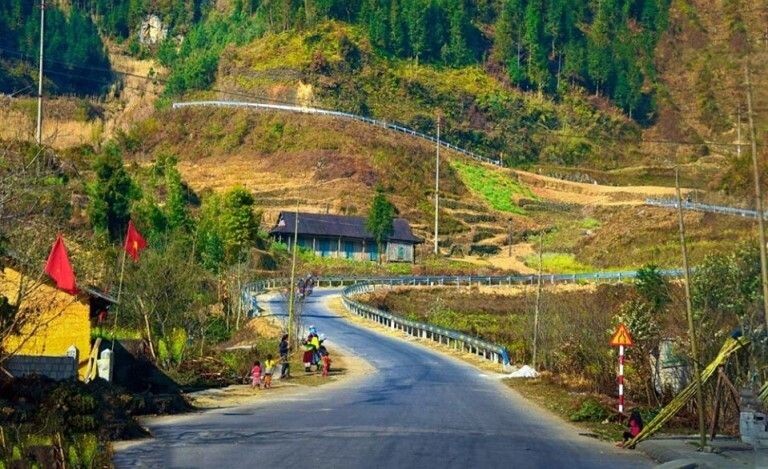
Tam Son – Yen Minh (50 km)
When standing at the top of the Heaven Gate, one can enjoy a wide-ranging view of Tam Son town. The town appears as if the clouds have left their traces in the sky, with expansive pine forests extending over several slopes towards Yen Minh town, which can be reached by crossing the Can Ty Slope. Yen Minh town is an excellent spot for travelers to take a break, have lunch and rest while on their journey.
Dong Van – Meo Vac – Du Gia (92 km)
It’s an amazing experience to conquer the enchanting Tham Ma and Chin Khoanh Pass while also encountering diverse weather changes. A visit to Lung Cam Culture and Tourism Village is highly recommended where the locals add to the picturesque view with their vibrant traditional attire and flower arrangements.
You can gain valuable insights into local architecture and history by exploring Dong Van Karst Plateau, the King H’Mong Mansion and ancient houses in Pho Bang. The Lung Cu Flagpole, a monument that marks the northernmost point, is also an excellent place to relax.
Dong Van Ancient Town is a lively spot at night and is home to numerous inhabitants with tales that date back more than 100 years. You can also find some signature dishes there, such as thắng cố, cháo ấu tẩu to satisfy your taste buds.

Ideal itineraries for discovering Ha Giang Loop Map
Ha Giang is a stunning destination that offers breathtaking natural landscapes and a diversified culture. However, planning an itinerary to explore this region can be overwhelming. To help you make the most of your trip, here are two suggested tour itineraries: a 3-day and a 4-day tour of Ha Giang Loop Map.
3-day Ha Giang Loop
- Day 1 (130km): Ha Giang city – Bac Sum Pass – Quan Ba Heaven’s Gate & Twin Mountains – Can Ty Lonely Tree – Tham Ma Pass – Lung Cam village & Pao’s House – Vuong’s Family Palace – Lung Cu Flag Tower – Dong Van Ancient Town
- Day 2 (101km): Dong Van Ancient Town – Ma Pi Leng Pass – Nho Que River – Skypath – Meo Vac – Du Gia Village
- Day 3 (120km): Du Gia Waterfall – Duong Thuong Valley – Lung Tam Linen weaving Craft Village – Yen Minh Town – Ha Giang City

4-day Ha Giang Loop
- Day 1 (140km): Ha Giang city – Bac Sum Pass – Quan Ba Heaven’s Gate & Twin Mountains – Can Ty Lonely Tree – Tham Ma Pass – Lung Cam village & Pao’s House – Vuong’s Family Palace – Lung Cu Flag Tower – Lo Lo Chai Village
- Day 2 (60km): Extreme North of Vietnam – Dong Van Ancient Town – Nho Que River – Ma Pi Leng Pass – Skypath – Meo Vac
- Day 3 (80km): M-shaped Bend – Duong Thuong Valley – Du Gia Waterfall
- Day 4 (120km): Du Gia – Lung Tam Linen weaving Craft Village – Yen Minh Town – Ha Giang city

5-day Ha Giang Loop
- Day 1 (112 km): Ha Giang City – Bac Sum Pass – Lung Khuy Cave – Yen Minh Town
- Day 2 (60 km): Yen Minh Town – Tham Ma Pass – Sa Phin – H’Mong King Palace – Lung Cu Flagpole
- Day 3 (53 km): Lung Cu – Dong Van town – Ma Pi Leng Pass – Meo Vac
- Day 4 (73 km): Meo Vac – Mau Due – Du Gia
- Day 5 (73 km): Du Gia – Ha Giang City

How to get around when discovering the Ha Giang Loop Map?
The decision to drive yourself or take a tour in Ha Giang depends on personal preference and circumstances.
Having a Ha Giang Loop Tour
On the other hand, taking a tour can be safer and more comfortable, as you don’t have to navigate and can pay more attention to the scenery. Additionally, tours ensure that you see all the sights and places that you may miss if you drive yourself. Tours can be on the back of a motorbike or in a car or minivan with a driver.
Hiring an easy rider (highly recommended)
Going on a motorbike tour with an experienced Ha Giang easy rider is recommended for the best Ha Giang loop experience. This option allows you to see more of the area than if you were driving yourself, and it’s also safer as there’s no need for motorbike driving skills or license.
The advantage of a motorbike over a car is that you have unobstructed views on both sides, more freedom to stop when you want, and the ability to ride on roads that cars cannot. Additionally, traveling on a motorbike provides an authentic local experience that is hard to replicate with other modes of transportation.

Ha Giang Loop Tour by car or minivan
Hiring a car or minivan with a driver can be a good option for comfortability and protection from weather factors. The prices for car or minivan rental with a driver vary depending on the duration of the trip, type of vehicle, and where you arrange it. It is recommended to book through a reliable travel agency or online platform to ensure safety and quality of service.

Self – driving on Ha Giang Loop Map
Driving yourself on a motorbike can provide a greater sense of adventure and is cheaper than taking a tour. However, it is important to note that in Vietnam, you are required to have a Vietnamese driver’s license to drive a motorbike legally, and your travel insurance may not cover you in case of an accident without one.
Having a Ha Giang motorbike tour is one of the most thrilling experiences you can have in Vietnam. But this adventure is only recommended for experienced and confident drivers. The mountain roads in Ha Giang are some of the most dangerous in the country, so it’s not the best place for beginners to learn how to drive.
You should also have experience with semi-manual or full-manual motorbikes, as automatic bikes are not recommended for navigating the steep mountain terrain. Keep in mind that while local authorities may tolerate foreigners driving, it’s technically against Vietnamese law to drive without a Vietnamese driver’s license.
In other words, you could be fined and your insurance may not cover you in the event of an accident. It’s important to do your research and read up on the rules and regulations before embarking on this incredible adventure.

It’s necessary to check:
- Engine capacity
- Stability and control of brakes
- Lights and direction indicators
- Tires and frame
- Gasoline leaking
Motorbike rental fee for exploring Ha Giang Loop Map:
Generally speaking, the rental price for a motorbike in Ha Giang is affordable, depending on the type of motorbike you choose. Here are some estimated prices for different types of motorbikes:
- Semi-automatic scooters: 180K VND (~ $7.57)
- Automatic scooters: 350K VND (~ $14.71)
- 150cc motorcycles: 550K VND (~ $23,12)

DISCLAIMER: Keep in mind that prices can vary depending on the season, availability, and negotiation skills. It’s always a good idea to compare prices from different rental shops and read reviews from previous customers before making a decision.
When is the ideal time to explore the Ha Giang Loop Map?
Ha Giang experiences two distinct weather seasons – the wet and dry seasons. It is advisable to avoid the wet season for safety reasons and for your comfort. It is important to note that the weather in Ha Giang town is not indicative of the weather in the mountains due to the changing altitudes and mountainous terrain, which can make the weather unpredictable even during the dry season.
The months from February to May are generally dry with clear skies. The later in this period you travel, the warmer it gets, which is important to note because the mountains can get chilly when you’re riding a bike.
The summer months of June, July, and August are humid and rainy. Thunderstorms and landslides are frequent, and temperatures can rise above 30 degrees Celsius. Road safety is now in doubt, so unless you’re a particularly experienced rider, we wouldn’t advise traveling then.

The months of September through November are suitable for completing the loop. Less rain is falling, and the weather has marginally cooled from the steamy summertime temps.
No rain fell while I was there in November, and the weather was largely sunny with a little haze. The entire time, the temperature was agreeable. Although there is minimal rain in the highlands in December and January, it can get chilly, especially at night.
I think that as long as you avoid the rainy season during the summer months, any other time of year is a perfect time to explore the Ha Giang Loop Map!

Practical tips for exploring Ha Giang Loop Map
Below are some practical tips that I got from my own experience. Hope that they could help you on your trip to Ha Giang:
- Drives between locations should always begin early in the day. You’ll be stopping a lot along the road, so I advise against driving at night as it’s very dangerous.
- As many of the towns don’t have a lot of accommodation available during the peak period, it’s probably a good idea to reserve a room a few days in advance. Although traveling during the low season, all the accommodations I could find were fully booked.
- While the Ha Giang Loop is a popular route, it’s important to note that the road conditions can vary greatly depending on the weather and time of year. Be prepared for uneven surfaces, potholes, and steep inclines and declines.
- Phone signals can be spotty in Ha Giang, so don’t rely on your phone for navigation or communication. It’s a good idea to bring an offline map and install an offline translation app.
- While there are ATMs in some of the larger towns in Ha Giang, it’s important to bring enough cash for your trip in case you’re unable to find one. Homestays and local restaurants may not accept credit cards.
- Ha Giang is home to many ethnic minority groups, each with their own customs around food and drink. Be respectful of these customs and ask your hosts for guidance.
- The weather in Ha Giang can be unpredictable, so it’s important to bring appropriate clothing and gear. This may include waterproof clothing, warm layers, and sturdy hiking shoes.
- The people in Ha Giang are friendly and welcoming, and are often happy to offer help and advice to travelers. Don’t hesitate to ask for directions or recommendations.

That’s my ultimate guide for the Ha Giang Loop Map. I hope you enjoy reading this article and find some useful information. Hope that you will have an unforgettable trip to Ha Giang!


